Never look at the local Chiselborough walls in the same way again?
by Martyn Morris
Uniformitarianism is a geological theory that describes the processes shaping the earth and the universe. It states that changes in the earth's crust throughout geological history have resulted from the action of uniform, continuous processes that are still occurring today. Its main proponents were the Scottish Geologists Charles Lyell (1797-1875) and James Hutton (1726-97), who are commonly acknowledged as being the fathers of modern geology.
One of my introspections on a career as a geologist is how my training has opened another dimension, one not seen or contemplated by most. This is a privilege and an ability to see into the past, led by clues in places where most would not even know to look. One such place is Chiselborough and the surrounding villages, more specifically there is a story to be revealed from the very building stone that many of our houses and garden walls are built with.
Unfortunately, much of this building stone is weathered and covered in lichens, moss and grime but if you were to take a fresh cut through it or if you are lucky to have some rock that has been recently cut with a diamond saw or cleaned with acid there is much to be revealed in the fresh rock faces.
Blandly described, these rocks are quarried from the Ham Hill Limestone Member, they are sedimentary in origin and were deposited between 174Ma and 183Ma (million years ago) during the Jurassic.
However, look a little closer and the story gets more interesting. I will start with just a few things that can be seen in the rock faces (also see picture examples) and then explore and unpack what each of these observations can tell us.
1. An abundance of shell fragments mostly smashed up with very few complete well preserved specimens
2. Interesting medium to large scale cross bedding and foresets
3. Clay rip-up clasts in a cleaner matrix of course grained shelly limestone
4. Secondary features such as small-scale fissures with quartz crystal growth and gypsum “desert rose” type crystals growing into fissures or vugs formed by shells.
With a polarising microscope and some geological thin sections there would be a lot more to discuss but for the purpose of this piece, let us keep it simple.
Firstly, the shell fragments and the occasional well preserved fossil, tell us a lot about the age of the rock. When dating a rock palaeontologists are guided by not just the individual fossils present but by the assemblage or combination of fossils. These days the date of appearance and extinction of different species is well known and when used in combination with the known ages of geological beds above and below the formation you are interested in, it is relatively easy to arrive at a bracketed age range. It is worth mentioning here that whilst macro fossils are useful, microscopic nanofossils (especially calcareous unicellular planktonic alga) are a better tool and allow ages to be narrowed down more accurately. The Ham Hill stone has many fossils visible to the naked eye, these include but are not limited to, ostracods, brachiopods, belemnites and ammonites. What we do know is that the latter two organisms became extinct at the same time as the dinosaurs disappeared (circa 65-67Ma), so if they are present in the Ham Hill stone then the rock had to be older than that. It turns out that a particular ammonite, Dumortieria, has been found in the Ham Hill stone and it only lived from about 180.1 to 175.6 million years ago. So that single species pretty much nailed down the age of the rock, without needing support from nannofossil assemblages. As we talk about the age of the stone in your wall, it is worth reflecting on what was going on in the world around it, at the time it was deposited. Early mammals had made an appearance 40Ma earlier and the super continent of Pangea was starting to break apart. North Africa was still joined to present day Newfoundland but at 170Ma the north Atlantic and the Gulf of Mexico started to rift apart. The first birds, placental mammals and flowering plants (angiosperms) would make their respective debuts 30, 40 and 47 million years later, by which time the Ham Hill stone was probably buried and well on its way to being a consolidated rock.
All of the first 3 observations noted above also tell us a lot about the environment that your piece of wall was formed in. This is the link to the two geological sages and their theory mentioned in the first paragraph. Shells are not only present; they are abundant albeit busted up and fragmented. Cast your mind to what would cause that? Secondly there is cross bedding on both a meso-scale (in our walls) and on a fairly macro scale, in some of the quarry faces on Ham Hill. What is cross bedding and what is the significance of it? From modern day analogues we know that cross bedding indicates bimodal current direction, usually caused by tides. Given the granular coarseness of the rock material and that some of this cross bedding is on a large scale (0.5m or so high) this has to indicate a fairly high energy environment, one with crashing waves and strong tidal currents. Furthermore, the abundance and type of fossils present point toward a warm shallow sea, possibly in a tropical setting. The best present-day analogy of that type of depositional environment that I can think of, is the Bahamas. So, when you walk out on a gloomy day, sit down on the wall, and imagine you are sitting on a shelly sandy bottom in crystal clear, warm, neck deep Bahamian water. You would be sitting on the same sediment, as it was the day it was deposited, just without the neck deep warm water and with a mere 174 million years or so of time separation.
It is worth briefly mentioning the secondary features. The Ham Hill Stone is generally flat lying with horizontal bedding (Figure 1, after Prudden, see below). It is only about 25m thick and is of very limited areal extent, a unique more erosionally resistant capping than the surrounding rock and found nowhere else in England other than on Ham Hill, Chiselborough Hill, Gawlers Hill and Chinnock Hill. It has not be subject to any major tectonic events or folding however there is evidence that during the Tertiary Period, 66 to 2.58Ma there was some strike slip movement on the deep seated basement faults in Somerset (Figure 2, Prudden’s sketch map, below). It is likely that during these events some compressional forces and associated hydrothermal activity caused fracturing and stylolites. Some of these fractures and some of the better preserved shells that formed vugs, were then filled with quartz which crystalized as this hydrothermal activity waned.
I have attached some examples below of the things that I have spoken about above. These are all from the walls and external stairs of our own house in North Street.
I have hitherto spoken only of the Ham Hill stone, primarily because it is omnipresent in everything that surrounds us in Chiselborough. It would be remiss however not to briefly mention the Yeovil or Bridport sands upon which the Ham Hill Limestone member rests and which are the bedrock upon which Chiselborough is built. Unlike the Ham Hill Limestone Member, which is very limited in areal extent, the Yeovil sands are the intermediate member of a common depositional sandstone system that extends southward (and becomes younger) from Bath to the Dorset coast, where the sands are known locally as the Midford and Bridport sands respectively. The British Geological Survey now classify all these sands under the common name Bridport Sand Formation. Outcrops (albeit poor exposures) of these sands can be seen in the Holloway (Hollow Lane) between Ham Hill and Montacute but also locally in the Holloway between Chiselborough and West Chinnock (Skillgate Lane). The Bridport Sands generally lack any internal structure. The were deposited in a shallow marine sand bar setting and the lack of internal structure is attributed to them being extensively bioturbated. Bioturbation is the extensive burrowing by marine worms and other organisms that either destroys or modifies the primary depositional features of a sediment.
Hasslet (1996) also notes that the Inferior Oolite which is younger than and overlies the Ham Hill limestone occurs in patches on Chiselborough Hill and at West and Middle Chinnock. The Inferior Oolite is present in many locations in between southern Somerset and the Dorset coast and it is noted as a particularly good source of well-preserved fossils, in particular, ammonites. Oolites (from the Greek for egg) are marble like balls formed in warm, supersaturated, shallow, highly agitated marine intertidal environments. As they are rolled around on the sea bottom, they accrete successive layers of limestone. They are present in the Bahamas and are still being formed there today, another example of uniformitarianism. Anyone who can show the author the abovementioned outcrops would be greatly appreciated, although they may be on private property.
So, this is an out of practice geologist, and new to Chiselborough resident’s, take on the geology that surrounds us. If you have managed to get this far, congratulations and I am hoping that you will never think of the Ham Hill Limestone walls in quite the same way again.

Figure 1

Figure 2
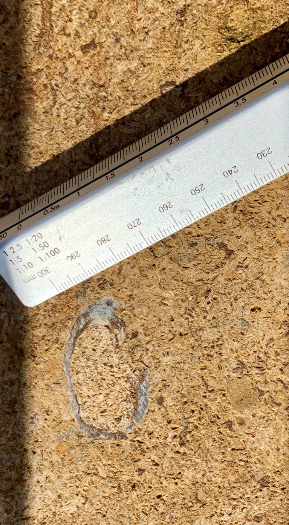
Picture 1
Ham Hill Stone showing that it comprises almost entirely of shell fragments cemented together with calcium carbonate cement. The large fossil near the end of the ruler is an ostracod (a cut section through an ancient oyster)
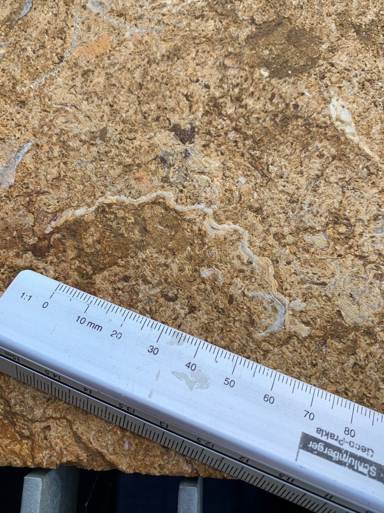
Picture 2
The wavy edge of a clam like shell (bivalve). This is the equivalent of a modern day Pecten shell, more commonly called a scallop and the symbol for the oil company Royal Dutch Shell.

Picture 3
Cross bedding or Herringbone bedding indicating bimodal currents during deposition. It is not the best example but enough to send you looking for other examples hopefully.

Picture 4
This is a large rip-up clast. It originates when a strong current flows over an existing semi-consolidated clay bed and the current rips or tears chunks of the underlying rock out of the channel floor and deposits it within the matrix of the coarser shell material

Picture 5
Secondary fractures possibly related to the compressional events caused by movement on the deep seated strike slip faults in the Somerset area during the Tertiary period
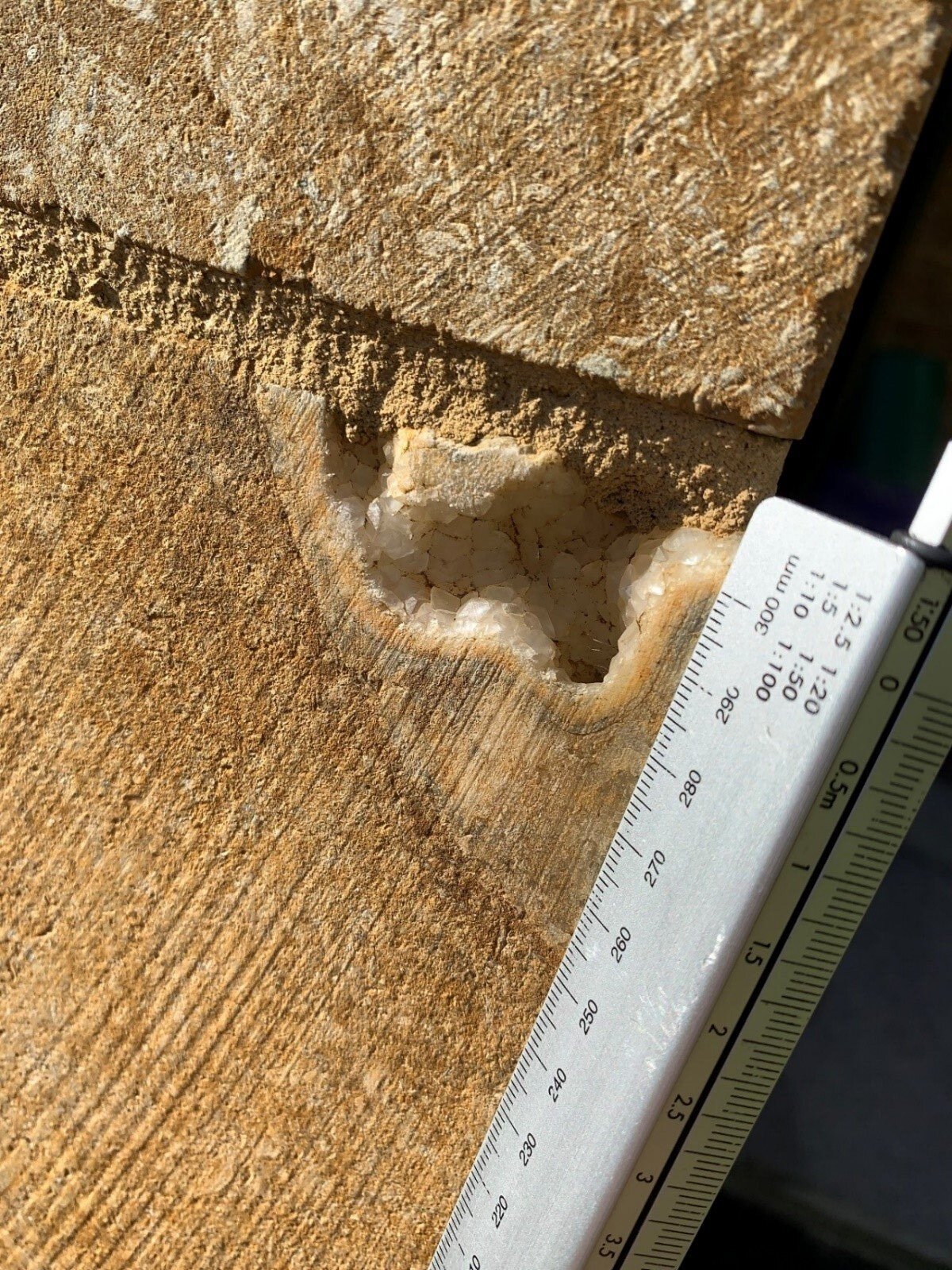
Picture 6
Quartz crystal growth occurring in the vug or void underneath a large ostracod shell. It is not difficult to see the (inverted) cup-like wall of the oyster shell that has created the void in the rock for the quartz crystals to grow freely into. This is also common in ammonite fossils. This type of crystal growth in fractures and voids is associated with hydrothermal fluids and escaping steam that make their way up to the surface by exploiting or creating fractures in the overlying formations. These hydrothermal events are often triggered by tectonism in the deep seated layers closer to the mantle.

Picture 7
Modern ooids from a beach on Joulter's Cay, The Bahamas
References
Prudden, Hugh. (n.d.) A GEOLOGICAL GUIDE TO HAM HILL COUNTRY PARK (Open university https://ougs.org/files/wsx/reports/Ham_Hill-4-7-15.pdf)
Haslett, S. 1996. The geology of Ham Hill. The Somerset Magazine, 6, 26-27.
K.M.Cohen, S. Finney, P.L Gibbard (2015) International Stratigraphic Chart. (Int. Commission on Stratigraphy)
British Geological Survey. iGeology App Ver. 6.0.2. Geological Maps of Great Britain