Manor Farm Field Names
Like most farmers, Louise & Richard Holloway know every field by its name. Some of the names have changed over time, and some have an interesting back-story. Here you can discover for yourself the names of the fields that are the major part of our landscape.
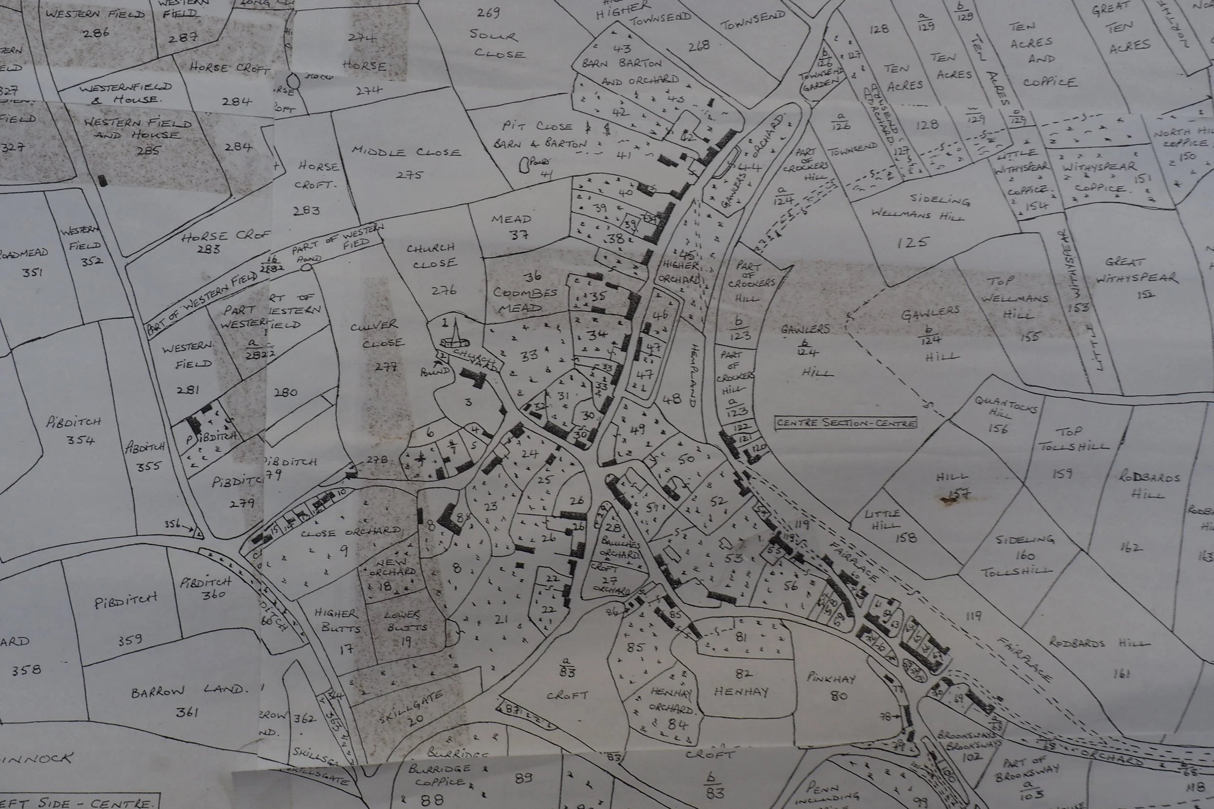
See the field map below, with the names handwritten by Louise & Richard over each field. This is best viewed on the large screen—the detail will be impossible to see on a mobile.
For even clearer study, below this map are two close-up views of the same.
Below this, for comparison you’ll find an 1843 map, showing the names at that time, and the slightly different configuration.
Finally at the foot of the page, Louise and Richard have listed all the current field names, with notes.

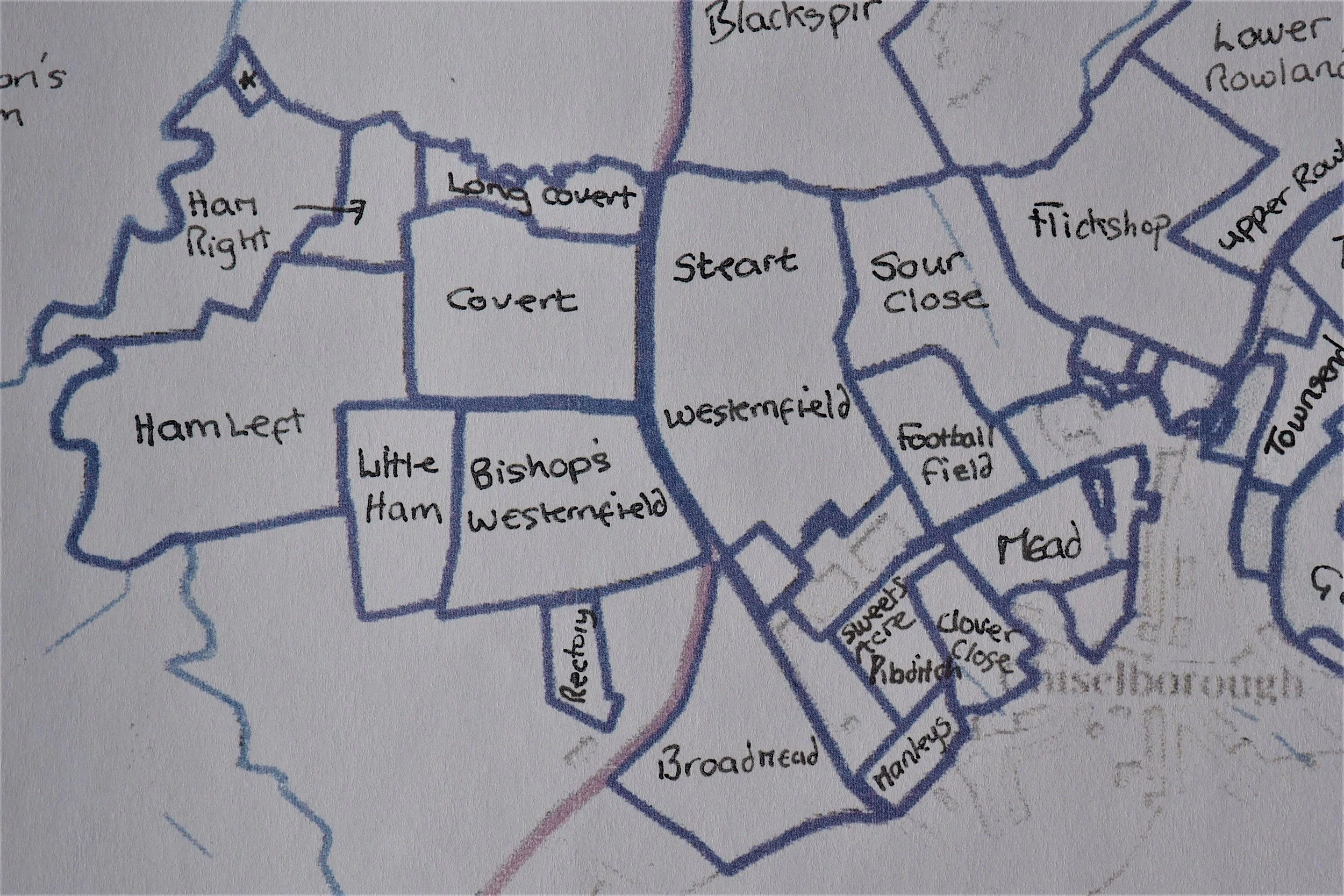
A close-up view of the western half of the above map.
For example, we can see Flickshop, opposite Townsend Villas. Also Westernfield and Steart on the right of the A356 as one drives up to the A303, and Bishop’s Westernfield and Covert are opposite, on the left of the road. Clover Close lies to the side of the church, behind The Court House.
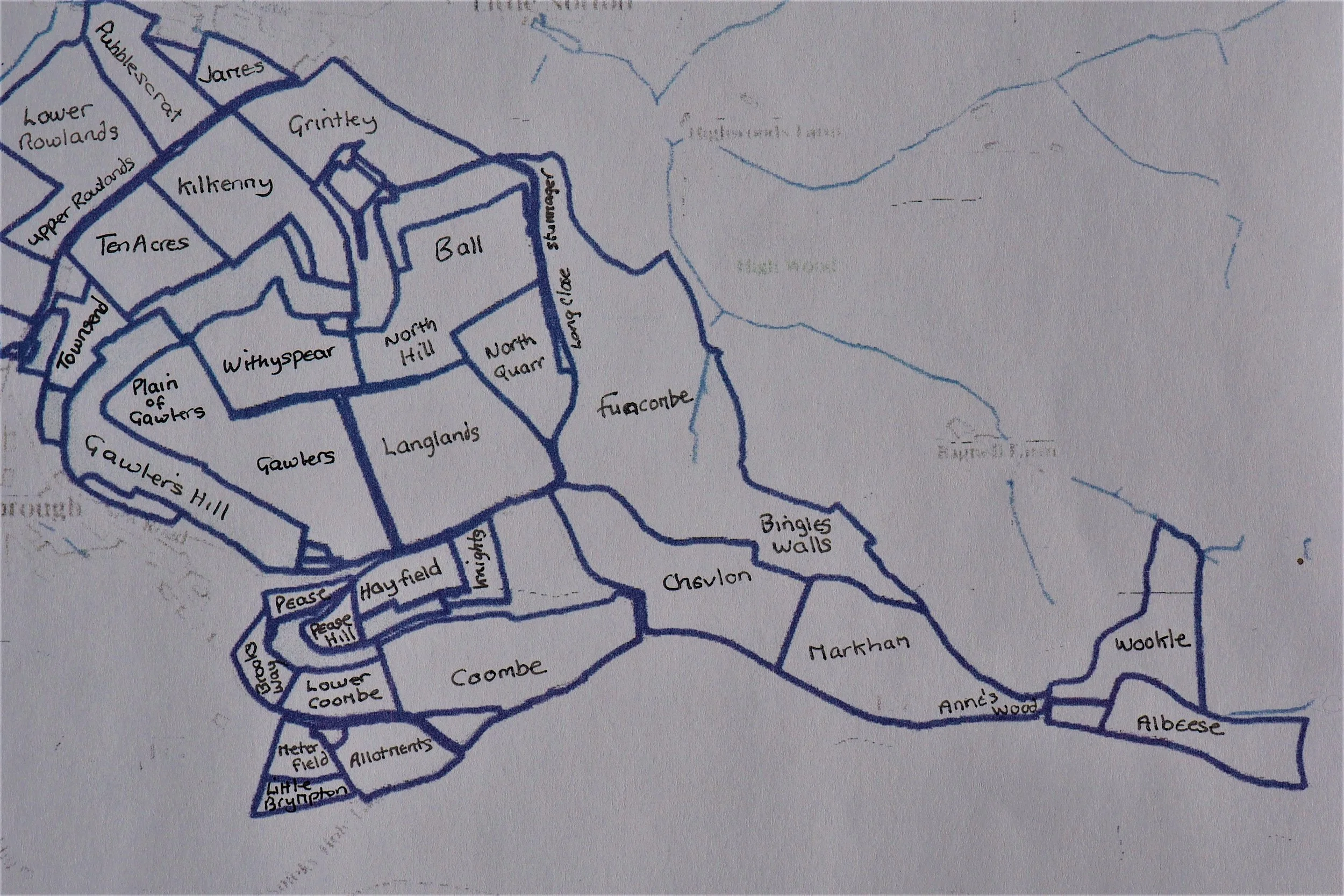
A close-up view of the eastern half of the above map.
Here we can see Coombe on the left of Smokey Hole Lane, then Chevlon, Markham, Anne’s Wood, Wookle and Albeese above Bagnell Farm.
After Townsend Villas, on the lane to Norton on the right side lie Ten Acres, Kilkenny and Grintley.
For fascinating comparison, below is the central section from a hand-drawn map of Chiselborough fields, dated 1843. It was compiled by John Martin of Evershot, a Land Surveyor. Martin undertook substantial work for the Earl of Ilchester. There are many differences to the contemporary map above: for example, you’ll notice that this pre-dates the road we know as the A356, and several field boundaries have changed.
Manor Farm Field Names - current list - by Louise and Richard Holloway
Albeese - All by East
Wookle - Oakhole
Markham
Chevlon
Funcombe
Ball and North Hill
North Quarr - was a quarry
Langlands - often mispronounced ‘Langdons’ presumably due to it being a local name.
Coombe
Lower Coombe
Brooksway
Knights Ground - was Little Don but we tend to call it Knight’s as we bought it from a Mr. Knight.
Hay Field - was part of Pease Hill but now Hay Field, as Rosemary Burns used to make her hay there.
Chelsea Allotments
Meter Field - has a meter in it!
Anne’s Wood - trees planted in memory of Anne Holloway.
Brympton Hill
Clover Close - was Culver Close
Stummager, Long Close and Bingles Walls all now part of Funcombe.
Withyspear
Gawlers was several fields, as was Gawlers Hill.
Grintley
Kilkenny
Ten Acres
James’ Ground was owned by the father of the two Miss James who ran the village pub. Also known as Box Hats as Mr James used to wear a box hat.
Top and Lower Rowlands
Pubblescrat - People’s Crat
Flickshop - was Flax Shop or flax works
Sourclose
Football Field - was Middle Close and Horse Crat then became Football Field as the village team played there.
Westernfield
Steart
Covert - probably derivative of Coleford
Rectory Field was part of Broadmead but we call it Rectory as it is by the old rectory
Broadmead - was partly Broadmead and part Pibditch